Puncak Jaya or Carstensz Pyramid Climbing Season & Difficulty – My Trip
Originally when the Seven Summits were first climbed, Mt. Kosciusko was chosen as the peak for this region since it was the highest in mainland Australia at 7,310 feet or 2,228 meters. As a Seven Summit, Mt. Kosciusko was hardly a challenge with a parking lot serving as its base camp and the summit reachable in only a few hours of easy hiking. The difficulty though is irrelevant; being the highest peak of Australia Kosciusko had earned its title, but this didn’t very last long. Soon after the Seven Summits were first conquered, climbers began to consider the entire continent of Oceania which added such places as New Zealand, New Guinea, and countless other Pacific Islands instead of mainland Australia.
With more than double the height of Kosciusko, and the highest peak in all Oceania, Carstensz Pyramid became the true summit of the continent. While the vast majority of climbers agree with this choice, there are still a few who like to argue. Some dislike the idea of the Pacific islands being part of a continent and hold on to Mt. Kosciusko as the true summit. A ridiculous few even accept the island of New Guinea to be part of Oceania, but they believe that since the western half is politically occupied by Indonesia, Carstensz is therefore in Asia. Those select few conclude that Mt. Wilhelm in the eastern side of the island is the true summit of Oceania.
In my opinion, Carstensz Pyramid is the obvious choice as the summit of Oceania for the following reasons. Geographically the island of New Guinea is located on the Indo-Australian plate, which makes its location in the continent unquestionable. Taking it a step further, the land is culturally native not to Asians but to Papuans who are descendants of aborigines from Australia. The final argument about the western half of New Guinea being part of Indonesia can be solved easily with a few examples.
Indonesia has only occupied western Papua, as they call it, since the 1960s. Indonesia’s presence here is relatively new, especially when you consider that Carstensz Pyramid has existed for millions of years. Using this ridiculous logic though, Carstensz Pyramid would have been the highest mountain in Europe prior to 1960 since the Dutch controlled western Papua, and the Netherlands is a European country. Even if you did agree political boundaries, the locals do not consider themselves Indonesians and instead Papuans.
Only days before my trip, several tribes banded together and once again declared independence from Indonesia. This resulted in martial law and nearly caused my entire trip to be canceled. Each to his own of course, but I personally feel anyway you look at the matter they all point to Carstensz being the true summit of Oceania, and with that in mind, I set off one October to attempt what would be my fifth of my Seven summits.
Sugapa
Click here to see the trek through the Villages
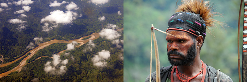
For those that do the real climb, you’ll begin in one of the villages dozens of miles from the mountain itself. My adventure began in the village of Sugapa, where we were went through nearly a dozen road blocks and were forced to pick up local porters to join our expedition. This interesting cultural experience was the last stop before entering the untamed lands of Carstensz Pyramid.
The Rainforests
Click here to see the trek through the Rainforests
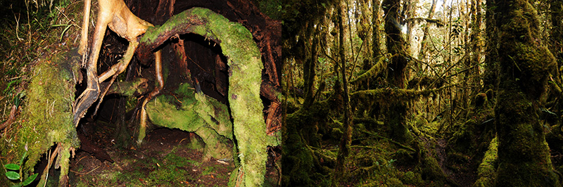
The rainforests of West Papua are some of the wettest places on earth. Unlike most other wet places in the world, heavy rains occur throughout the year and there is no dry season. This brings lots of deep mud and misery for trekkers in the already difficult terrain.
The Highlands
Click here to see the trek through the Highlands
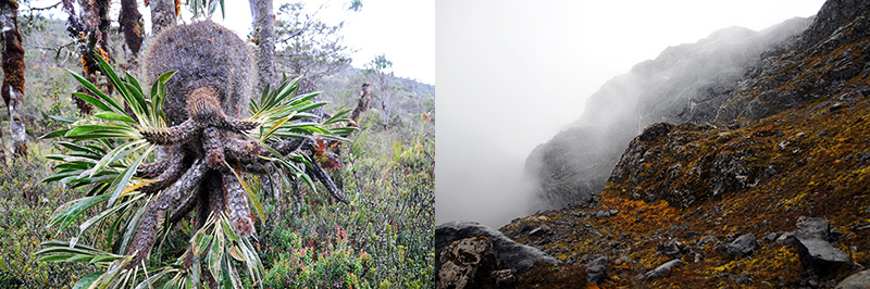
The highlands bring just as much rain and mud as the rainforests but with colder temperatures. The terrain is a bit flatter with less vegetation to obstruct wonderful views of the interesting landscape. During the trek through the highlands you’ll even pass elevations over 14,000 feet (4,000 meters), or higher than the top of Mt. Rainier.
The Summit
Click here to see my summit of Carstensz Pyramid
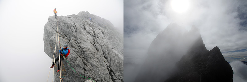
The final push! Beginning very early into the morning, the near vertical climb up Carstensz Pyramid to the summit begins. The climb includes jamaring up walls, lots of scrambling, and even a Tyrolean traverse on the way up to top of Oceania.